
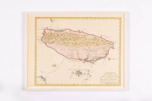
Haarlemmermeer municipality map
Updated at 2026-04-13
5660
Haarlemmermeer is a municipality in the Netherlands’ low-lying western region. It was constructed in the 1840s on land reclaimed from water. The name “Haarlemmermeer” means “Haarlem’s lake,” referring to the body of water from which the region was reclaimed. Locals joke that “God created the world, and the Dutch created Haarlemmermeer.” This map shows Haarlemmermeer’s scenic spots, including Hoofddorp’s town square, Museum De Cruquius, and Fort Vijfhuizen.
Name
Haarlemmermeer municipality map
Giver
Theo Weterings Mayor Haarlemmermeer
Friendly States
Kingdom of the Netherlands
City
Municipality of Haarlemmermeer
Language: Dutch
Area: 206 square kilometers
Population: Approx. 170,000 people
Main Industries/Features: Haarlemmermeer is where the world-famous Schiphol Airport, which integrates transportation, industry, and urban development, is located. It's a paragon of an airport city.
Category
Paintings、Paper
HIGHLIGHTS
相關藏品

.JPG)

.jpg)
.JPG)
.JPG)


.JPG)